Topcon Base & Rover
Topcon Base & Rover
The Topcon Base & Rover is the foundation of any grade control system. It is a must-have if you want to get the best grade control possible. Simply put, the machine receives the corrections from the base and the rover is used to set up the jobsite and layout survey and control points.
In construction, efficiency is the most important aspect of any job. The cheaper the costs of staking, surveying, labor, and everything else, the more efficient you are. And the best place to start being as efficient as possible is here; with the Topcon Base & Rover.
For longer jobs, putting in a permanent mounting post eliminates having to set up a tripod each and every day for your daily surveying. Not doing that can lead to issues if it's not set up properly. But with the Base & Rover from Topcon, you just set it up once and you're good-to-go.
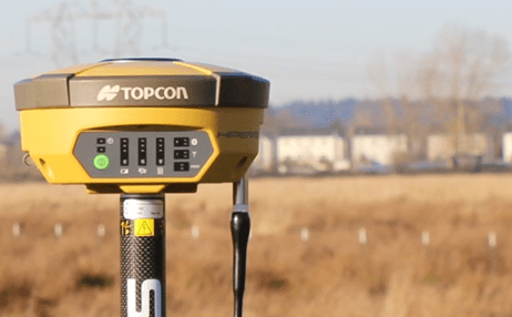
The Base & Rover is comprised of two main units: The HiPerVR GNSS Antennas and the Field Controller6000 (FC6000) Data Collector.
HiPerVT GNSS Antenna:
The HiPer VR is compact, light, and packed with the most advanced GNSS technology in a design built to withstand the harshest field environments. Using Topcon’s advanced GNSS chipset with Universal Tracking Channels Technology, the HiPer VR automatically tracks every satellite signal above – now and into the future.
All signals, all satellites, and all constellations — in a compact, rugged design, with an integrated IMU and eCompass.
The HiPer VR is a complete solution and versatile in many ways. It can be used for static or kinematic GNSS post-processed surveys, as a network RTK rover with the FC-5000's internal 4G/LTE cellular modem, as a UHF/FH/Longlink jobsite RTK rover, and also in Topcon’s patented Hybrid Positioning workflow.
Top features include:
- Universal tracking technology for all satellites and constellations (GPS, GLONASS, Galileo, Beidou, IRNSS, QZSS, SBAS) covering all modernized signals
- Field-tested, field ready IP67 design
- Compact form factor ideal for Millimeter GPS and Hybrid Positioning
- Revolutionary 9-axis IMU and ultra-compact 3-axis eCompass
- Integrated 400 MHz UHF Tx/Rx Radio Modem
- Integrated License-free 900 MHz Radio Modem, FH915 protocol 1
Topcon Inertial Leveling Technology (T.I.L.T.)
By combining a 9-axis inertial measurement unit (IMU), along with a digital compass, the HR can accurately compensate for up to 15º of tilt on the rod. Now you can measure all the way to a building edge without using an offset. Or stretch to get an otherwise out-of-reach point. Just as with many other Topcon technologies, T.I.L.T. is designed to solve real-world challenges, so your work gets easier, faster, and better.
FC6000 Data Collector:
Powerful, tough, and versatile, the FC-6000 brings the processing speed expected in the office directly to your project site. Your daily field computer just arrived and is set to impress.
- Sunlight readable 7 in. display
- Intel® Quad-Core Pentium N4200 Processor
- MIL-STD-810G and IP68 certified
- Windows® 10 operating system
- 8 MP rear camera, 2 MP front camera
- Integrated 4G LTE cellular module
- External Keyboard and docking station
(click here for more information) - Also available in the Android platform
Some Tips from 4Sight Solutions:
- Ensure you get the correct files from your engineer and/or surveyor.
- Good quality and properly formatted files for easy plug-n-play for contractors.
- Established survey and control points on the jobsite.
- Surveyed with both HUBS and control points.
Reach out to the 4Sight Solutions team to get started or request a demo with the Topcon Base & Rover.